


Earthquakes since time immemorial have scared and traumatised humankind because of the havoc they unleash. It is not surprising that in the past it was recorded for posterity like the way it is done today, and the evidence of this is a pictogram.
The pictogram accounts for Americas’ oldest known earthquakes.
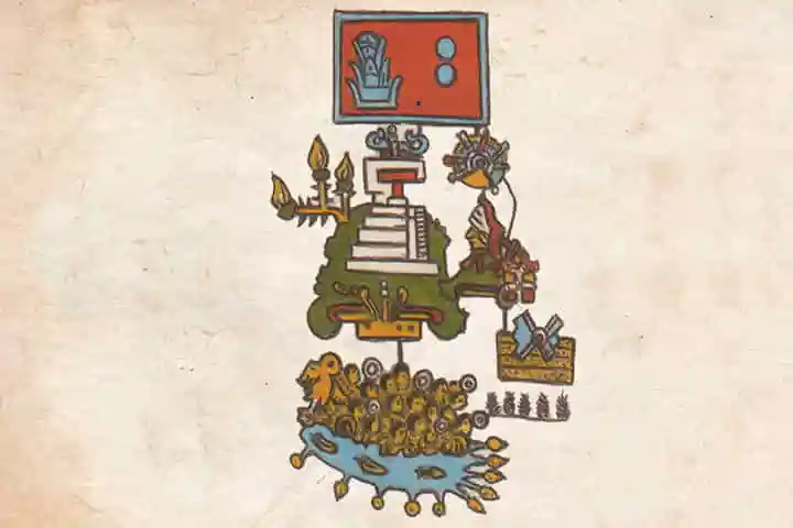
According to an article in sciencenews.org the codex of complex and colourful pictograms is of 50 pages. Dating back to the early 16th Century, it has the oldest and complete written chronologies of Americas’ early earthquakes.
Called the Telleriano-Remensis, its creators are unknown pre-Hispanic civilization, and it reports about 12 separate earthquakes that took place in the present day Mexico and Central America from a period 1460 to 1542. This was reported by researchers in Seismological Research Letters on August 25.
The codex was written in a language spoken by the Aztecs and other pre-Hispanic civilisation in the region which is known as Nahuatl, by specialists who were referred to as tlacuilos.
Interestingly, tlacuilos means “those who write painting”.
With the help of other codices from the region, the experts were able to decipher and identify a combination of two pictographs that stand for an earthquake. One depicts four helices around a central circle or eye, and this stands for ollin, which in Nahuatl means “movement”.
Also read: Study suggests that ancient Dravidian language was used in Indus Valley
In the other pictograph, one sees one or more rectangular layers filled with dots. This denotes tlalli, or “earth”. The earthquakes that happened during the daytime are indicated with the eye open. In the case of night time ones, the eye is closed.
The Telleriano-Remensis was studied thoroughly by seismologist Gerardo Suárez of the National Autonomous University of Mexico and social anthropologist Virginia García-Acosta of the Center for Research and Higher Studies in Social Anthropology. Both these institutions are located in Mexico City. The experts and researchers were in search of representations of quakes. They compared their find to the accounts of quakes that find mention in pre-Hispanic codices and with texts which were written later by Spanish friars.
By using pictorial representation of a 52-year cycle, the Telleriano-Remensis dates the quakes roughly. Four signs are used to represent the years. These are namely — tecpatl (knife), calli (house), tochtli (rabbit) and acatl (reed) — arranged in 13 permutations. Those images proved helpful to the experts and researchers to match some pictorial accounts of quakes, including one in 1507, to later descriptions of the events.
Also read: Mexico commemorates Spanish conquest by building an Aztec temple in its Capital
Besides the time, the pictograms also recount a little more about the precise locations of these quakes or the damage they caused even though there is one image that suggests that a quake had triggered flooding and drowned warriors.
Researchers feel that there may be other codices that contain more clues, and a study of these will help reveal and create a complete picture and chronology of the events of earthquakes that took place in this ancient world.


